The shape of Qinghai Lake is like an ellipse, with 109km length from west to east and 65km width from north to south. It's said that the lake seems to be a giant aspen leave floating on the grassland. The scenery of the lake is quite different in different seasons. In summer and autumn, trees grow flourish on mountains and grassland, which seems to be a thick carpet with colorful flowers as decoration. At the side of the lake, hordes of cows and horses drink water and eat grass. Large scale of farm lies beside the lake. The golden corn field likes wave when wind blows. In winter, the leaves begin to fall from trees. In Nov, the lake begins to freeze. At that time, the lake is like a mirror shining in the sunshine.
If you ever went to Guide County, you would know the earth movement more clearly. Some time later, another earth movement made Riyue Mountain rise. As a result, the only entrance of Qinghai Lake was closed. The mineral material at the bottom of the lake syncretize into the water, which makes it a salt-water lake. There are about 30 rivers in the Lake District, including Buha(Mongolian word, means urus) River, Shaliu River, Ha’ergai River, Quanji River, Ji’ermeng River and etc. In Jun and Jul, Huang fishes travel backward and lay eggs at the beginning of river. The willows on the bank, beautiful flowers, and the cool weather together with picturesque scenery make it a perfect resort. There are five islands in the lake: Dan Island, Lugu Island, Haixinshan Island, Sankuaishi Island and Sha Island.
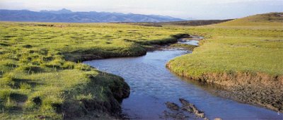
Buha River
Buha River is the longest river in Qinghai Lake area, which is originated from snow-capped mountains, flowing about 228km and passing 4000 sq km. In Jun and Jul, large amount of "huang" fishes swim against the stream and lay eggs there.
|