Introduction of Qinghai
Lake
Qinghai Lake is the largest endorheic lake and salt-water lake
in China. Its voluminous and misty scenery likes a tear on the surface of the earth.
Located on the Qinghai-Tibet Plateau, Qinghai Lake has a acreage
of 4456 sq.km and perimeter of 360km, which is more than two time
of the famous Tai Lake. The average depth of Qinghai Lake is about
16m, with the deepest point to 28m. The poundage reaches 71.9 billion
stere. The altitude of Lake Surface is 3260m, which approximates
to two height of Mount Tai. The weather is very cool here due to
the high altitude. Even in midsummer, the average temperature is
just 15 degree centigrade. It’s a perfect resort for passing the
summer in a leisurely way.
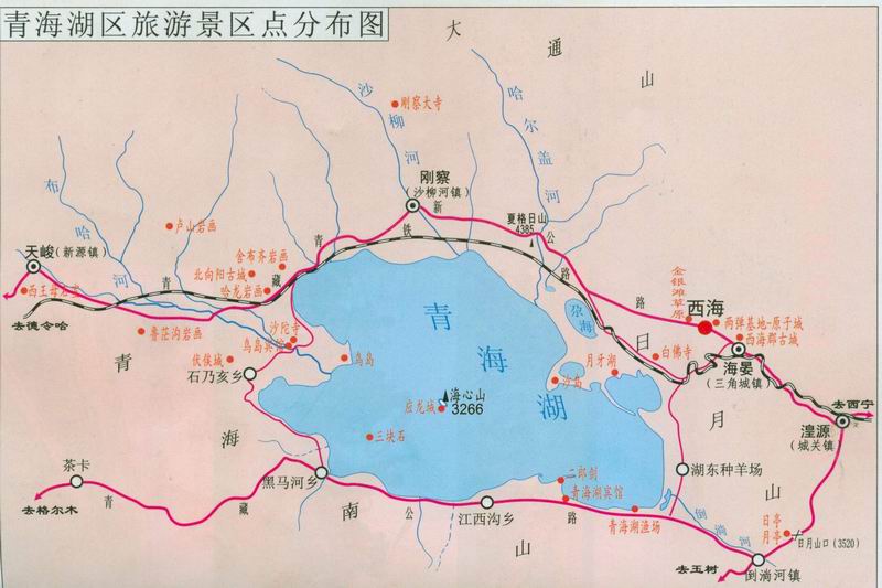
Qinghai Lake is on the northeast of Qinghai-Tibet Plateau. The
lake is surrounded by four lofty mountains, with Datong Mountain
on its north, Riyue Mountain on its east, Qinghainan Mountain on
the south and Xiangpi Mountain on the west. The altitude of these
four mountains is from 3600km to 5000km. These four mountains like
four barriers carrying Qinghai Lake in their arms. From the root
of mountain to the Lake, there is vast and flat grassland. The green
and wavy lake is similar to a grand jade lying between mountains
and grassland. 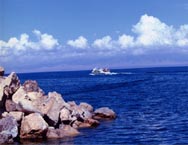
The shape of Qinghai Lake is like an ellipse, with 109km length
from west to east and 65km width from north to south. It’s said
that the lake seems to be a giant aspen leave floating on the grassland.
The scenery of the lake is quite different in different seasons.
In summer and autumn, trees grow flourish on mountains and grassland,
which seems to be a thick carpet with colorful flowers as decoration.
At the side of the lake, hordes of cows and horses drink water and
eat grass. Large scale of farm lies beside the lake. The golden
corn field likes wave when wind blows. In winter, the leaves begin
to fall from trees. In Nov, the lake begins to freeze. At that time,
the lake is like a mirror shining in the sunshine.
Qinghai Lake originally was a lake connected with sea. Because
of the earth movement, mountains raised and the lake became an endorheic
one. In the lake, there is a special kind of “Huang”fish. In order
to adjust to the environment, the fish took off its squama. Its
appearance is similar to carp with black dots on its back.
According to “Dange’er Ting Record” in 1910, Mongol caught this
kind of fish and sold them to big cities including Xi’ning and Lanzhou.
These fishes were made dry in summer and frozen in winter. Every
year, they could catch about 200,000 fishes. From 1960 to 1962,
China was in quite difficult period due to natural disaster. At
that time, the fish became the main source of local people’s living.
From Jun to Oct in 1960, people caught 1,060,000kg.The fishes grow
very slow (it reaches 1kg after ten years) due to the low temperature
of the lake. Nowadays, we need to control over-fishing and protect
this species. Many travelers in Qinghai want to have a taste of
this delicious fish. 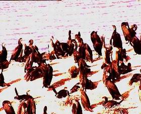
Qinghai Lake had many names in ancient times, including “Xihai”,
“Wuhai”, “Xianhai”, and “Xianshuihai”. Tibetan calls it “Cuowenbo”,
which means green lake. Mongol calls it “Kukunuo’er”, which means
blue sea. Beihe minority call it “Beiheqiang Hai”. Han minority
call it “Xian Hai”. From Wei Dynasty (220AD), the name was changed
to Qinghai Lake. In 1929, Qinghai Province was founded. Its name
originated from the lake. Qinghai Lake is the symbol of the province
and the pride of the people.
How does Qinghai Lake form? It’s believed that it was formed in
210,000 to 350,000 years ago. In far ancient, it was part of Mediterranean
Sea. In the 3rd century, Alps Movement made Qinghai-Tibet Plateau
rise. A large amount of sea fell down and formulated Qinghai Lake.
At the beginning, the lake was connected with sea. The water ran
from Qunai River to Huang River, and finally entered sea.
If you ever went to Guide County, you would know the earth movement
more clearly. Some time later, another earth movement made Riyue
Mountain rise. As a result, the only entrance of Qinghai Lake was
closed. The mineral material at the bottom of the lake syncretizes
into the water, which makes it a salt-water lake. There are about
30 rivers in the Lake District, including Buha(Mongolian word, means
urus) River, Shaliu River, Ha’ergai River, Quanji River, Ji’ermeng
River and etc. In Jun and Jul, Huang fishes travel backward and
lay eggs at the beginning of river. The willows on the bank, beautiful
flowers, and the cool weather together with picturesque scenery
make it a perfect resort. There are five islands in the lake: Dan
Island, Lugu Island, Haixinshan Island, Sankuaishi Island and Sha
Island.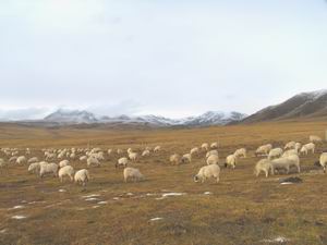
On the bank of Qinghai Lake, there are vast natural pastures,
corn fields, and abundant mineral resources. The sufficient precipitation
is crucial precondition of developing stockbreeding and agriculture.
In ancient, it was the important producing area of livestock, including
horses, cattle, sheep and etc. The local horses (called Qin Horse)
were very famous for sturdiness and gallop since in Ch’un and Ch’iu
Period (Spring and Autumn Period in 221BC). In following Sui (618AD)
and Tang Dynasty (907AD), the local horses were mated with “Wusun
Horse” and “Xuehan Horse”. Their physical strength improved a lot.
There was a famous “horse and tea exchange” market in Huangyuan
County on the way to Xi’ning. At that time, Tibetans used strong
horses to exchange tea with local merchants. The trade was very
busy. Nowadays, local people begin to invest in modern industry,
like mines, feather factories, and mechanic repair services.
|